


For generations, mainstream historians and archaeologists believed that the dense wilderness of the Amazon rainforest was historically incapable of supporting large-scale human societies. However, recent technological breakthroughs have uncovered breathtaking lost Amazonian cities hidden beneath the canopy.
However, a revolutionary technological breakthrough has completely destroyed this myth. By using advanced laser scanning, scientists have mapped vast, interconnected lost Amazonian cities, revealing a highly sophisticated, agrarian civilization that thrived thousands of years ago through these lost Amazonian cities.
This isn’t science fiction; it is one of the most significant archaeological breakthroughs of the 21st century.
Inside the Upano Valley: The Network of Lost Amazonian Cities
The turning point in Amazonian archaeology came when an international team of researchers published their findings on a sprawling urban network in the Upano Valley of Ecuador, situated in the foothills of the Andes.
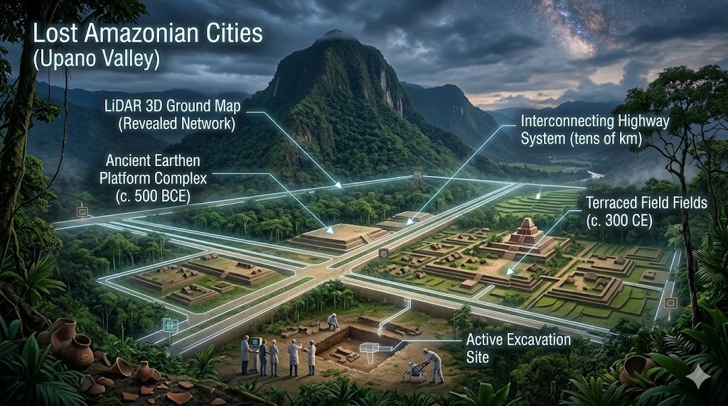
As detailed in the official research published by the Science Journal – Amazon Urbanism Report, the scale of this ancient society is staggering:
- Age: The urban settlements date back over 2,500 years (roughly 500 BCE to 300-600 CE).
- Interconnected Infrastructure: Scientists found more than 6,000 earthen platforms, plazas, and monumental complexes.
- The Highway System: What shocked researchers most was a massive network of straight, wide roads connecting different garden cities, stretching over tens of kilometers.
This tells us that the pre-Columbian Amazon was not an untouched wilderness, but a heavily managed, populated landscape of highly organized urbanism.
The Science Behind It: How LiDAR “Peels Back” the Jungle
How do you find a lost city hidden beneath a canopy of millions of trees? You cannot see it from space with normal satellites, and exploring on foot takes decades. The secret weapon is LiDAR (Light Detection and Ranging).
The UKRI (UK Research and Innovation) and global archaeological teams have backed massive aerial mapping projects using this tech. Here is how LiDAR works:
- Laser Pulsing: An airplane equipped with a LiDAR scanner flies over the rainforest, firing hundreds of thousands of laser pulses per second down at the ground.
- Data Filtering: While many lasers hit the dense leaves, a small percentage slip through the gaps and bounce off the actual forest floor.
- The 3D Map: A computer calculates the exact time it takes for each laser to return. It then uses algorithms to digitally “delete” the trees, creating a highly precise 3D map of the bare ground.
Through this process, hidden canals, defensive structures, terraced fields, and ancient highways instantly become visible to researchers.
Separating Fact from Fiction: Who Built These Cities?
Just like the recent discoveries found inside the Great Pyramid secret chamber, these ancient ruins have gone incredibly viral, leading to internet forums frequently claiming they are connected to mythical legends like El Dorado…
Because these discoveries have gone incredibly viral, internet forums frequently claim these ruins are connected to the mythical “El Dorado” or built by ancient astronauts.
The scientific truth is far more fascinating. These cities were built by complex indigenous societies, such as the Kilamope and later the Upano cultures.
According to global archaeological networks like Antiquity Journal, these people were expert engineers. They built with earth because stone was scarce in the region. They engineered complex drainage systems and canals to combat the heavy tropical rains, and they engaged in widespread agriculture, growing maize, manioc, and sweet potatoes.
The Next Steps: What This Means for History in 2026
As LiDAR mapping projects expand, it is becoming increasingly clear that we have only scratched the surface. Experts estimate that thousands of ancient settlements remain completely undetected under the canopy.
This discovery fundamentally shifts our understanding of human history and sustainable urban planning. It proves that ancient humans could build sprawling, highly populated garden cities inside a rainforest without completely destroying the ecosystem—a lesson modern climate scientists are looking closely at today.
This historic revelation completely transforms our perspective on pre-Columbian South American urban engineering.